McMurdo AIS AtoN
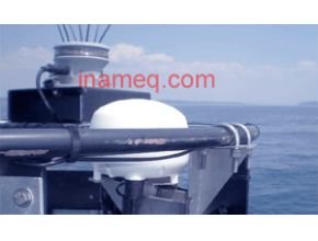
The McMurdo AIS AtoN (Aid to Navigation) is an IALA compliant beacon that is designed to be installed on navigational hazards, offshore wind farms, oil and gas platforms/pipelines etc as well as fixed or floating aids to navigation such as buoys and markers, further enhancing their operation by alerting any AIS equipped vessels that are within range, while also providing additional data such as position, current status, real time warnings and reducing the risk of collision even in poor visibility.
There are two models available – the Kanaton 1 is an AIS transmitter only and the Kanaton 3 is a transmitter/receiver which allows it to be remotely controlled from a shore station network. The Remote Monitoring System uses a web-based application to receive the AIS data relayed from the AtoNs which is designed to be compatible with any new and current Aid to Navigation systems.
The units include a VHF and GPS antennas and are supplied with the necessary cables and connectors, along with any necessary hardware and software for configuration, testing and maintenance. The AtoNs can also be linked with a range of sensors, providing up to the minute hydrological, meteorological and other environmental data to the shore station. This real-time data can be used for a wide variety of purposes apart from navigational use including environmental protection and monitoring, navigation study and analysis, economic optimisation and more.
- Kanaton 1 – AIS transmitter.
- Kanaton 3 – AIS transceiver.
- Can be linked with additional sensors.
- Remote control and configuration from shore station (Kanaton 3 only).
- Can transmit the following AIS data :
- Message 21 Identification of the aid to navigation (name, type, position etc).
- Message 8 Meteorological and hydrological data.
- Message 6 Telemonitoring of AtoN.
- Message 12 Relaying of safety messages transmitted by a SART (Kanaton 3 only).
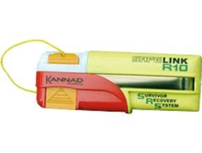
Kannad Marine SafeLink R10 AIS MOB Device
Kannad Marine R10 AIS MOB Device
Introducing the SafeLink R10, the first of its kind, a personal AIS (Automatic Identification System) device designed to be fitted to a lifejacket and assist in Man Overboard recovery.
The SafeLink R10 transmits target survivor information, including structured alert messages, GPS position information and a unique serialised identity number back to the onboard plotter*. An inbuilt high precision GPS receiver provides accurate position information to assist in quick recovery of survivors.It will transmit continuously for a minimum of 24 hours and has a 7 year battery storage life.
It also features a flashing LED indicator light; to aid detection at night and a self test facility with battery use indication.
How It Works
Carrying a SafeLink R10 is a must for every safety conscious sailor. using this simple to operate, yet state of the art new device ensures the ultimate chance of retrieval in a Man Overboard situation. View the demonstration.
How SafeLink R10 Works
-
SafeLink R10 must be mounted on a lifejacket using the attachment clips provided, prior to going to sea
R10 is activated manually in an emergency situation. -
A unique emergency alert is transmitted to all AIS receivers and AIS enabled chart plotters within a 4 mile radius (typical).
-
An AIS SAR emergency icon signals the requirement for urgent help in a Man Overboard situation. Precise target survivor information including GPS position becomes viewable when the chart plotter* cursor is positioned over the emergency alert icon Provides exact location, range and bearing to locate person(s) in need of assistance.
-
The SafeLink R10 can be manually activated in two easy steps; when installed in the lifejacket the orange safety tab should be released, this ‘arms’ the R10 ready for use. To use, first inflate the lifejacket. When it is inflated, pull the orange tab downwards to pull the red cap off the R10. This will deploy the antenna and automatically switch ON the R10 SRS.
-
If professionally* fitted to a lifejacket, the R10 can become semi-automatic in operation; the action of the lifejacket inflating triggers the activation of the R10.
Automatic Activation Supported Lifejackets (PFDs)
Providing it is professionally fitted, by the lifejacket manufacturer or one of its authorised service centres, the R10 can be made to activate when the lifejacket inflates. This makes the R10 as automatic as the lifejacket, activating as a result of the lifejacket being inflated.
Specifications
| Environment | AIS message transmitted | Message 1 (UID, GPS position, SOG, COG, UTC) Message 14 (SART-ACTIVE or SART-TEST) | |
| Sealing depth | immersion to 5m (16.4 ft) | GPS receiver | |
| Operating temperature | -20°c to +55°c (-4°f to +131°f | GPS type | 50 channel |
| Storage temperature | -30°c to +70°c (-22°f to +158°f | Antenna type | ceramic patch |
| Battery | GPS position update | every minute | |
| Type | 6v Lithium Metal | Physical | |
| Replacement | By service centre | Size (D*W*L) | 27*47*124mm (1.1″ * 1.6″ * 4.7″) |
| Use | logged by microcontroller | Weight | 120g (4.23 oz) |
| Electrical | Functional | ||
| AIS Transmitter | First Transmission | After 10 seconds (no GPS) | |
| Frequency | AIS channel 1 -161.975MHz, AIS channel 2 – 162.025MHz | Range | 4 nautical miles (typical) |
| Power | 2W nominal | Secondary location | Flashing white LED |
| Transmit antenna | Sprung whip | Part Number: Safelink R10 SRS retail pack |
K98-001-001A |
Read More :